
.jpg)
Serengeti National Park - Tanzania
 Area: 14,763 km2
Inscribed: 1981
Criteria: (vii) aesthetic; (x) biodiversity
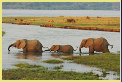
Values: Twice a year ungulate herds of unrivalled size pour across the ‘endless plains' of Serengeti on their annual migrations between grazing grounds which stretch from the Ngorongoro highlands in the south to Kenya's Masai Mara in the north. The migration involves more than a million large herbivores, with herds of wildebeests, zebras and gazelles, followed by predators. It is, without doubt, one of the most impressive wildlife spectacles in the world.
Other International Designations: MAB Biosphere Reserve
Slideshow of the Serengeti National Park
ADDITIONAL RESOURCES (pdf downloads)
 Serengeti Migration Explained: An explanatory brochure describing the ecology and funtioning of the Serengeti ecosystem can be downloaded by clicking here. It is based on the superb artwork and visitor interpretation provided at the Serengeti Visitor Centre at the Seronera park headquarters, compiled by Frankfurt Zoological Society. The brochure explains the main habitats, the interactions of its animals and the way the landscape and seasons 'drive' the migration.
 Visitor Information Brochure and Map: To download a 4-page visitor information brochure, which describes the main areas of the park and includes a map of the park roads and tourist facilities, click here.
 Maps & Satellite Images: A selection of maps and satellite images of the Serengeti National Park is available here. The portfolio provides detailed information on aspects such as road access, the relationship of Serengeti National Park with adjacent protected areas, and a month-by-month view of where the migrating herds of large herbivores are likely to be. The Google Earth satellite images show some of the main ecological features of the area, including the short grass plains, kopjies, lakes, woodlands and riverine gallery forests.
Quick Reference Scores: (for explanation see About Us)
|
Scenery |
Wildlife/Biodiversity |
Accessibility |
Facilities |
Integrity |
|
|
|
|
|
|
Links: Google Earth | UNEP-WCMC Site Description | Official UNESCO Site Details | Park Website | Management Authority: TANAPA | Frankfurt Zoological Society | Our Place Photos | Birdlife IBA


